Updated11/11/2025 00:52:00
 

No watches or warnings in effect for Toronto Island, ON.


You can translate the content of this page by selecting a language in the select box.

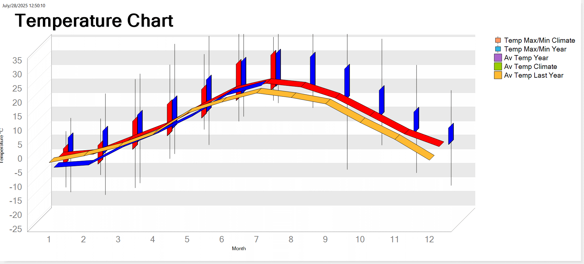
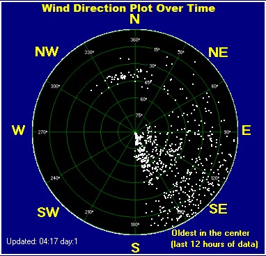
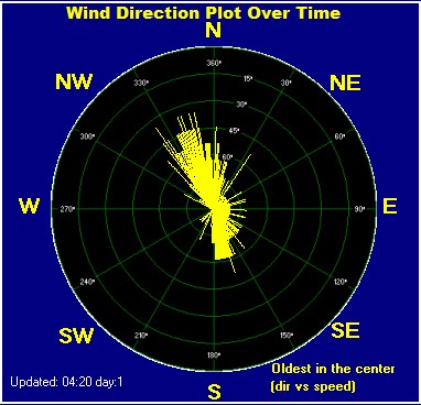
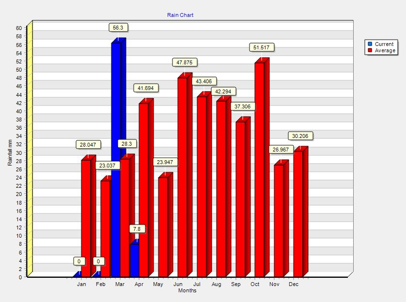
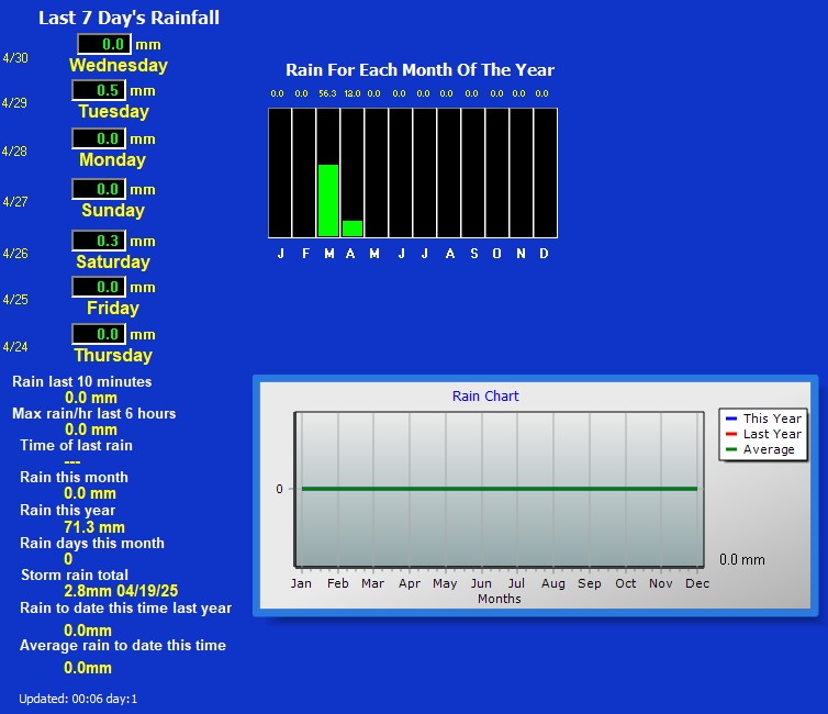
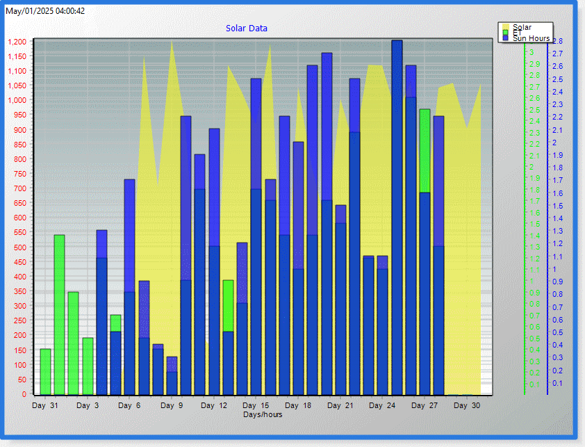
Summary / Temperature / EC Forecast / Webcam Wind-Sonic Anemometer Snow Radar / Lightning / Fire

Currently: -3.7°C, Max: -3.7°C, Min: -3.8°C Night time, Dry, Overcast

Temperature:   -4°C
Trends: Warmer 0.1 °C than last hour. Uncomfortably Cold Feels like:     -5°C
Aparent solar temperature: -6.6
Than yesterday: -0.2°CColder 0.2°C   than yesterday at this time.
Average Weekly Temp: 4.8°C
Record Month High Temp: 15.3°C
Record MonthLow Temp: -4.6°C
Humidex: -7.1°C
Daily high humidex: -7.1°C
Daily low humidex: -7.3°C
Heat Index: -4°C
Record hight Heat Index: 46.4
Record hight Heat Index Month: 6
Record hight Heat Index Day: 22
Record hight Heat Index Year: 2025
Year record high heat index: 46.4°C
Year record high heat index month:
Year record high heat index day: 22 
Year record high heat index year: 2025 
User daily report: ------


Temperature
  Today Yesterday
High: -3.7°C
00:13
-2.6°C
13:46
Low: -3.8°C
00:01
-4.6°C
07:41
Temp. interior: 18.4°C Time
Max.int: 18.5°C 00:00
Min.int: 18.4°C 00:19
All time Temp. Date
High 39.5° C 6.22.2025
Low -17.1° C 12.22.2024


 Wind from SSE SSE 4.3 Gust: 3.2 km/h
Beaufort: 1 Bft - Light Air
Today Avg: 13.0 km/h at  00:16
Max Gust last hour: 12.9 km/h
Max Gust yesterday: 22.6 km/h at  04:36
Average direction gust: NNW
Gust Month: 37.0 km/h Nov 5
10-min Avg: 2.8 km/h
15-min Avg: 2.8 km/h
30-min Avg: 3.5 km/h
60-min Avg: 3.5 km/h
120-min Avg: 4.6 km/h
Wind 5 min ago:           1.9 km/h
Wind 10 min ago:         3.7 km/h
Wind 15 min ago:         1.9 km/h
Wind 20 min ago:         3.7 km/h 1.9 km/h
Wind 30 min ago:         3.7 km/h
Wind 45 min ago:         1.9 km/h
Wind 60 min ago:         5.6 km/h
Wind 75 min ago:         3.7 km/h
Wind 90 min ago:         3.7 km/h
Wind 105 min ago:       5.6 km/h
Wind 120 min ago:       3.7 km/h
  
Snow Today: 2 cm
Snow Yesterday: 2 cm
This Month: 16 cm
Winter Total: 74.1 cm
Snow Depth: 6 cm
2 snow days in Nov.
12 snow days in year 2025
Estimated height snow: 123 cm
Current ET: 0.2 mm
Yesterday ET: 0.3 mm
ET for last 7 days: 3.7 mm
ET year to date: 424.3 mm
Solar energy number: 0 W/M2
Daily high solar: 0
Time that the daily high solar: 00:00
Current solar percent: 0 %
Vpsolar 30 min ago: 0
Vpsolar 60 min ago: 0
Vpsolar 90 min ago: 0
Vpsolar 120 min ago: 0
Sunshine hours to date day: 00:00
Sunshine hours to date month: 00:00
Daily lengt yesterday: 09:52:00
Click on images to zoom

GR3 Radar
Satellite IR
WU lightning map
Windy.com Map Temp. Wind
Zoom Map
Windy.com Map Rain
Weather Radar Windy.com
Radar.weather.gov Radar weather gov.
Satellite GOES 16 East GOES 16 East
Satellite GOES 16 Geocolor GOES East Geocolor
Satellite GOES 16 Visible GOES 16 Visible
Satellite GOES 16 IR GOES 16 IR
Accuweater satellite SIR Activity Map
Lightning maps
My nexstorm image
Pollution map
Latest Lightning Strikes
Lightening counts: 0
Lightening distance: 0 km
Lightening bearing :
Lightening counts last 30 min.: 0
Lightening counts last hour: 0
Lightening last 12 hours: 0
Lightening year: 82723
Lightening month: 0
Lightening count last time: 17:59:09 2025/18/06
Lightening strike max time: 00:52

Chandler Burning Index: LOW
FIRE
Current: 2.4
CBI Index
Currently: -1.6 at 00:52
Humidity & Barometer 
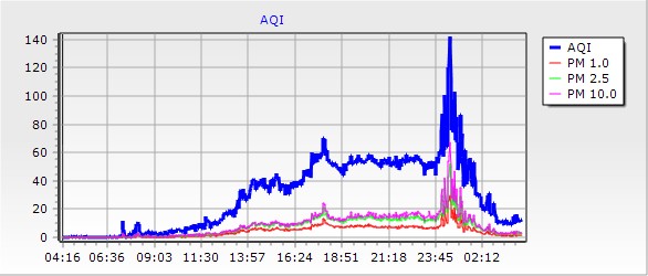
Cloud base & Air Quality
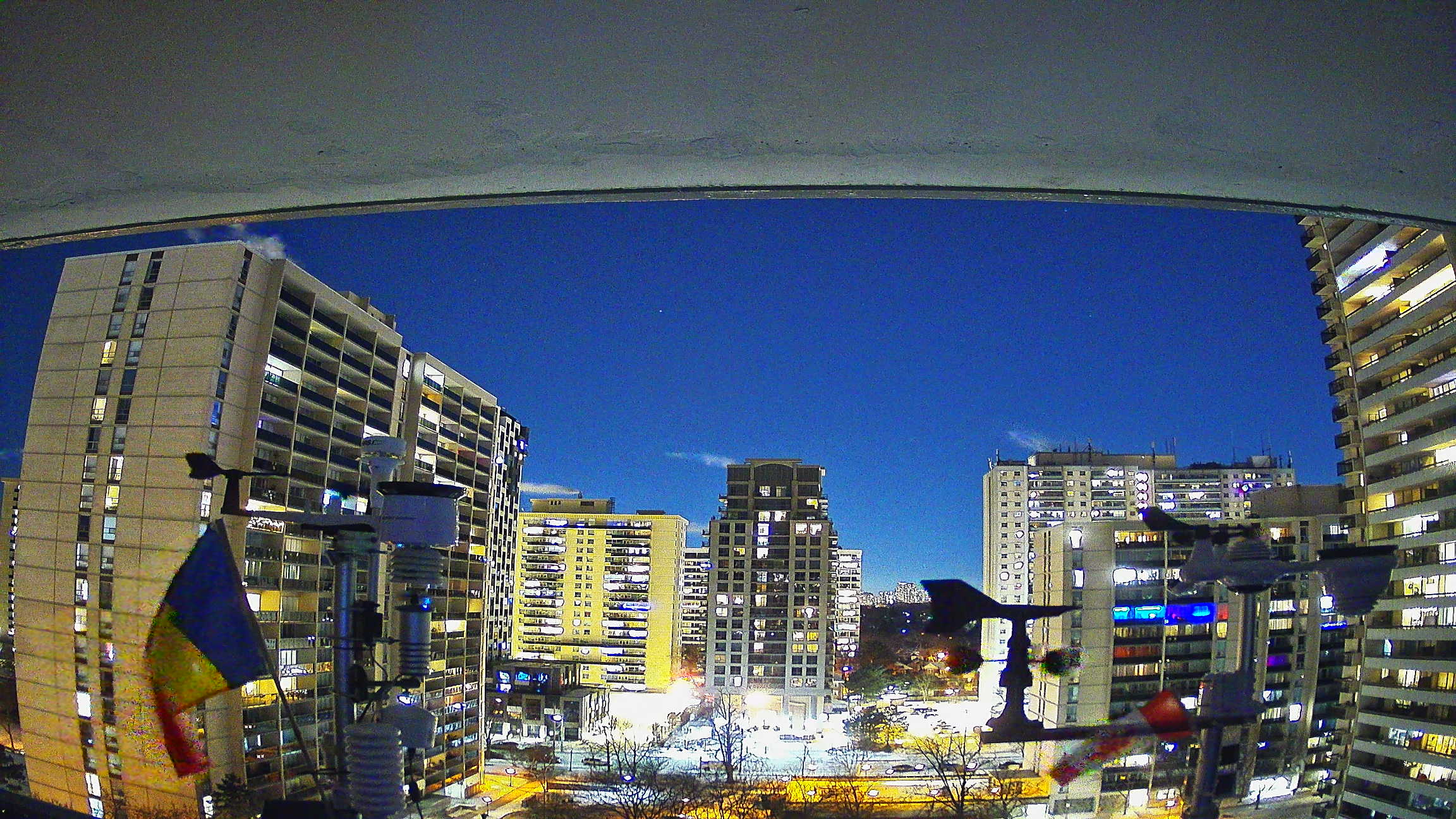
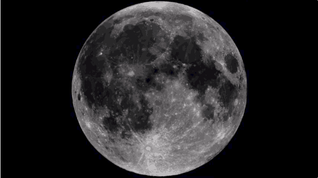
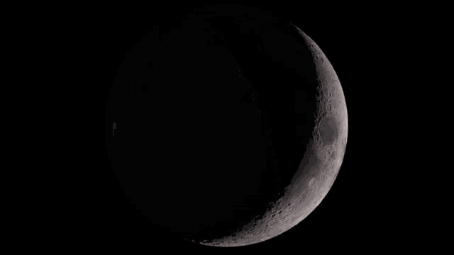
 Sun & Moon/Sun Plot

Humidity:   83 % Increased 1% since last hour.
Humid. 10 min ago: 82 %
Humid. 15 min ago: 82 %
Humid. 20 min ago: 82 %
Humid. 30 min ago: 82 %
Humid. 60 min ago: 82 %
Humid. 120 min ago: 82 %
Indoor Humidity: 23 %
Dew Point: -6.2°C Increased 0.2°C since last hour.
Wetbulb: -4.5°C
Barometer: 1010.9 mb Falling 0.5  mb/hr
Trend: -0.5mb/hr
Baro Trend: Falling slowly
60 min ago: 1011.4
90 min ago: 1011.6
120 min ago: 1011.8
Max. yest.: 1016.5 mb
Min. yest.: 1011.3 mb
Baro 3-Hr Trend: Falling
Record High Baro: 1045.1
Record Low Baro: 984.3
Air Density: 1.31


-->
Air Quality
PurpleAir Exterior
Loading PurpleAir Widget...
  
Waning Gibbous
Waning Gibbous, Moon at 21 days in cycle
                61%
               Illuminated
Moonrise: 22:04
Moonset: 13:15
Possible hours of Daylight
Sunrise Today:
07:07:20
Sunset Today:
16:56:48
Length of Day Yesterday:
09:49:28
Length of Day Today:
09:51:50
Day Length Decrease:
02:22 min


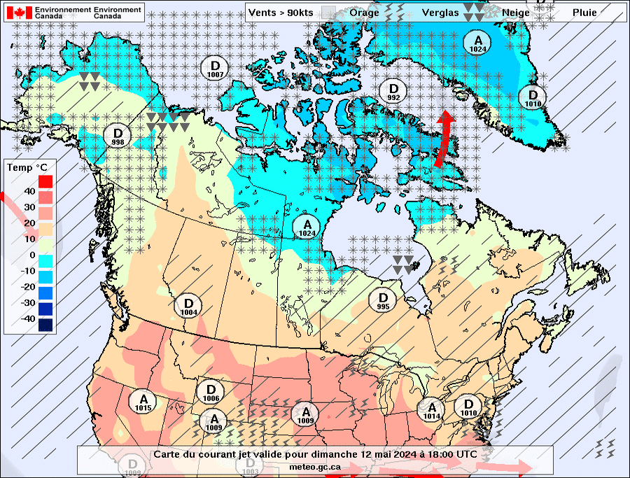
                        Environment Canada Forecast

 EC Extended Forecast & WXSIM Forecast  -   Tonight 's and Tue, 11 Nov's Outlook
Tonight
Chance of flurries (40%)
Chance of flurries
Min: -2°C
EC forecast: Mainly cloudy with 40 percent chance of flurries. Flurries beginning overnight. Local amount 2 cm. Wind northwest 20 km/h becoming light after midnight. Low minus 2. Wind chill near minus 8.
WXSIM forecast: Dense overcast. A chance of snow in the morning, then snow likely in the afternoon. Breezy. High 2°. Wind northeast around 20 kph, gusting to 36 kph. Chance of precipitation 70 percent. Precipitation (liquid equivalent) mostly around 10 mm. Snow accumulation 4 to 6 cm. Maximum freezing level 300 meters above sea level. Maximum snow level -50 meters above sea level.
Local station forecast: Mostly cloudy and cooler, precipitation likely, windy with possible wind shift to the w, nw, or n.
Tue, 11 Nov
Flurries
Flurries
Max: 4°C
EC forecast: Flurries ending in the morning then cloudy. Local amount 2 cm. Wind west 20 km/h becoming light in the morning. Wind becoming southwest 30 late in the afternoon. High plus 4. Wind chill minus 8 in the morning. UV index 1 or low.
WXSIM forecast: Dense overcast in the evening, becoming cloudy after midnight, with light to moderate frost. A chance of snow. Breezy and cold. Low -3°. Wind chill ranging from -8 to -5. Wind northeast around 22 kph, gusting to 38 kph, in the evening, becoming north after midnight. Chance of precipitation 50 percent. Precipitation (liquid equivalent) mostly around 2 mm. Snow accumulation about a cm. Minimum freezing level -300 meters above sea level. Minimum snow level -550 meters above sea level.
 EC Short Term Weather Forecast