Canada Flag       Ontario Flags

Updated:  3/29/2023 14:55:00
  Cloudy/Dry Temperature: 4.4°C Colder 1°C than last hour.   /hr Humidity: 75%Increased 11% since last hour. Dew Point: 0.4°CIncreased 1.2°C since last hour. Wind: S  7.6 km/h Gust: 8.0 km/h Barometer: 1012.3 mBFalling 0.5  mB/hr  Falling slowly Rain Today: 0.0 mm AQI: 61.3

Navigation

  • Home
    • Advanced
    • pwsWD-2022-01-23
    • FreshWDL
    • Weather in Ascii
  • *! NEW ! AND UPDATES *
  • About
  • Advisories, Warning
    • Special Weather Statements
    • Marine Warnings
    • Watches Warnings Advisories
    • WXSIM Risk
    • WindAlert
  • Air Quality
    • PurpleAir AQI sensor
    • PurpleAir AQI sensor interior
    • PurpleAir detail
    • Airly.com
    • PurpleAir comparasion
    • AirNow
    • Davis AQI sensor
    • EC- AQI Toronto
    • AQI Peak Ozone
    • Air AQICN
    • Aqicnworld
    • Aqicnstation
    • IQAir
    • Air Quality
    • AERONET
    • Ozone
  • Hi Low Avg
  • Almanac
    • Atmosferic optics
    • World Clock
    • Flight Tracker
    • ISS Tracker
    • Banner
    • Zambretti Forecast
    • Sager Forecast
  • Astronomy
    • Calendar Solar Eclipse
    • Solar systems
    • Solar PHP
    • Moon and Solar eclipse
    • Kp-index
    • Astrospheric
    • Sun Calc
    • AuroMAX
  • Analysis Forecast
    • NASA Maps
    • Weather Maps
    • Climate Reanalizer
    • Meteogram windguru
    • Meteogram generator
    • GFS-Meteograms
    • Forecast Models North America
    • 6-14 Day
    • Jet Stream
  • Console Live
    • VP Console2 Light
    • VP2 Console Light °F
    • VP Console
    • VP Console Light
    • 3D VP Console
  • Clear Sky
  • Dark Sky Forecast
    • DS-forecast
    • Dark Forecast
    • DarkSky-Map
  • Documentation
    • Cloud Classification
    • Precipitation type
    • Cycle Thunderstorm
    • Weather front
    • Weather terminology
    • Map Symbols
    • Bioindex
    • Weather Words
    • Beaufoort Scale
    • Dewpoint RelHumidity
  • EC Forecast
  • Earthquake activity
    • Last quake-EMSC
    • Earthquake activity
    • Volcanoes of World
    • Volcanoes of Canada
  • Fire Weather
    • Firework Ontario
    • Firework Canada
    • Firework Ontario 48 h
    • Firework Canada 48 h
    • Fire Danger Rating
    • Fire Smoke
    • FWI
  • Forecast
    • Forecast spotwx
    • Meteoblue Forecast
    • Mesowest
    • Meteomap.cloud
    • Forecast UCAR
    • NOAA Forecast
  • Forecast WXSIM
    • WXSIM V.7.3
    • WXSIM Hourly
    • Leuven forecast
    • Leuven forecast full
    • Meteogram Forecast
    • Code WxXSIM
  • Photos from Flickr.com
  • Forecast Compare Icons
  • FreshWDL NEW
    • FreshWDL-Danish
    • FreshWDL-Bulgarian
    • FreshWDL-Romanian
    • FreshWDL-Spanish
  • Global Networks
    • Global Networks Ontario
    • Global Networks NEWN
    • Global Networks World
  • Hurricane
    • Hurricane-infrared
    • NWS 24h
    • HAniS US WPC
    • Pacific Atlantic Temps.
    • Hurricane Canada
    • Satellite Tropical
    • Tropical Cyclone
  • Indoor temp , humid.
  • Lightning
    • Lightning Activity
    • Lightning Map
    • Map Lightning
    • Canada Lightning - ON
    • Storm Predicator
    • Fatal Tornado History
    • Lightning N-E America
    • Lightning North America
  • Links
    • Links
    • Forum Watch
    • Wxforum
    • Forum Astrogenic
    • WXSIM Forum
  • Marine
    • Buoys Data
    • AIS Traffic
  • Multiple graphs
    • Temperature
    • Humidity
    • Wind Speed
    • Wind Direction
    • Wind Direction and speed
    • Wind Chill
    • Rain Daily
    • Rain Monthly
  • Metar Reports-ON
  • Mobile Weather
    • Mobile Weather
    • Mobile WWL
    • New Mobile Weather
    • Mobile IWDL
    • Summary Weather
  • Netatmo Station
    • My Netatmo Station
    • My Meteoware
    • Netatmo Station Multilingual
    • Netatmo MAP
    • Netatmo Gauges
    • Alexa and My Weather Station Netatmo
  • New forecast scripts
    • Leuven icon only
    • Wxsim EC
    • Wxsim EC 7 day
  • Other Forecast
    • Four Day Map
    • Windy.com Forecast
    • Ventusky forecast
    • Clear Outside
    • EC-Deterministic-Forecast
    • Estimate Rain
    • Lake Forecast
    • Marine Forecast
    • UV Index Forecast
    • Pollen Forecast
  • Printable Flyer
    • Flyer with WXSIM
    • Flyer with EC
  • Records Station
  • Reports
    • Reports Station
    • testtags.php
    • Regional Summary
    • Freeze Data
    • Hot Days
    • Clientraw
    • Climatedataout
    • Dailynoaareport
    • Wind Chill
    • Summary weather
    • Ozone
    • Windfinder
    • Windsailflow
  • Radar
    • EC Radar Canada
    • Rainviewer
    • Zoom Radar
    • GRL3-Radar
    • Weather Channel Radar
    • Meteo and Radar
    • Radar-East
  • Solar radiation
  • Satellites
    • Satellite GOES-16 Big
    • Satellite GOES-16
    • Satellite GOES New
    • NOAA image of the day
    • Tracking ISS
    • Tracking Satellite
    • Europa satellite
  • Space Weather
  • Steel Series Gauges
    • Steel Series-English
    • Steel Series-Catalan
    • Steel Series-Czech
    • Steel Series-Danish
    • Steel Series-Finnish
    • Steel Series-French
    • Steel Series-German
    • Steel Series-Greek
    • Steel Series-Italian
    • Steel Series-Hungarian
    • Steel Series-Nederland
    • Steel Series-Norwegian
    • Steel Series-Portughese
    • Steel Series-Polish
    • Steel Series-Romanian
    • Steel Series-Slovak
    • Steel Series-Spanish
    • Steel Series-Swedish
    • Steel Series-Turkis
  • Snow Info and Ice
    • Snow In High Park Village
    • Snow analyse - Maps
    • Snow In Toronto
    • Count Snow In Toronto
    • Ice Conditions
    • Snow calculator
    • Snow to Rain
  • Station Status
    • Station Status
    • Check-fetch-times
  • Teleconnection
    • Artic Oscillation
    • North Atlantic Oscillation
    • Pacific North American Oscillation
  • Trends
    • Temperature and Rainfall Trends
    • Trends Today
  • TAF Metars
  • Utils
    • Weather Calculators
    • Humidex Calculator
    • Find lat and long
    • Coordinate converter
    • DST
    • SunCalc
    • Gold, Oil Prices
  • UV Index
  • Wind
    • Wind alerts
    • Global Wind Map
    • IKITESURF
    • Wind Map USA
    • Windyty maps
  • Wind Chill
  • WeatherFlow Station
  • Webcam
    • Three Webcam
    • Live Traffic
    • WZYZ Web cams
    • Balcony Web cams
    • Timlapse Webcam West
    • Timlapse Webcam S-W
  • WU
    • Wundermap
    • WU Map
    • Davis in WU
    • Netatmo in WU
    • WU Toronto
    • WU-History
    • Monthly Records
    • Yearly Records
  • Website Map


www.windguru.cz
www.awekas.at
www.Meteomap,,cloud.com
www.pwsweather.com


WXYZ WEB CAM Toronto
Webcams</ br> travel
Your browser does not support the audio element.

Counter Website

^^

Radar Symbols

What do the various lightning symbols represent?

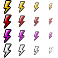
The above are lightning data symbols where (from top to bottom):

First Row Means 16-30 minutes old
Large Icons Mean 16+ strokes 
Second Row Means 11-15 minutes old
Medium Icons Mean 11-15 strokes
Third Row Means 6-10 minutes old
Small Icons Mean 6-10 strokes
Fourth Row Means 5 minutes or less
Tiny Icons Mean 5 strokes or less


What do the various storm symbols represent?
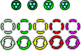
 

Green Circles:

The solid dark green circle means that there is 50% chance or greater of hail that is smaller than 19 mm (3/4 of an inch).

The hollow dark green circle means that there is between 30 - 50% chance of hail that is smaller than 19 mm.

The solid light green circle means that there is 50% chance or greater of severe hail (hail that is 19 mm or larger).

The hollow light green circle means that there is between 30 - 50% chance of severe hail (hail that is 19 mm or larger).

Coloured Rings:

The broken rings are shown when the base of a mesocyclone (a rotating thunderstorm) is aloft (ie. not on the lowest tilt).

The solid rings are shown when the mesocyclone base is on the lowest tilt.

The color "heat" of the icon represents the strength (very weak is light green, weak is green, moderate is yellow, strong is red, extreme is purple). GRLevel3 uses the "strength rank", SR, to choose an icon. The first icon is shown for SR values of 1-2, second for SR values 3-4, third for 5-6, fourth for 7-8, and fifth icon for 9 and above.

What is "Tilt":

This is a display of echo intensity (reflectivity) measured in dBZ (decibel scale). The base reflectivity images in GRLevel3 are available at four radar "tilt" angles, 0.50°, 1.50°, 2.40°, and 3.40°. A tilt angle of 0.5° means that the radar's antenna is tilted 0.5° above the horizon. Viewing multiple tilt angles can help one detect precipitation, evaluate storm structure, locate atmospheric boundaries, and determine hail potential.

Radar symbol explanations courtesy of Patrick Marsh of Forwarn.org


Random Weather Words

Cumulus Clouds
Fluffy, mid-level clouds that develop in towering shapes and signal fair weather. Cumulus clouds are a principle cloud type.

RSS icon RSS Current Conditions Weather Display v10.37S-(b147)

© 2023, celinmeteo.com - Marian Celin Peteanu, Vers.9.5 March 21 2021

Some information is provided by a private weather station and is not an officially recognized station for weather reporting.
Though we strive to achieve accurate reporting for our own use it is important that you do NOT
depend on the data provided here for any purpose.